Summer 2022

As part of the Gulf Scholars Program: Gulf Impact Project, this team of students examined Natural Hazards at Hazardous Installations (Natech) by mapping Aboveground Storage Tanks (ASTs) in Galveston County. They then used these maps and other data to create a variety of reference maps to set the scene and analytical maps showing expected spill volume of these storage tanks.
Thematic reference maps:
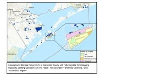
- Aboveground Storage Tanks (ASTs) in Galveston County with redlining data from Mapping Inequality, splitting Galveston City into “Best,” “Still Desirable,” “Definitely Declining,” and “Hazardous” regions.
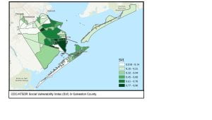
- CDC/ATSDR Social Vulnerability Index (SVI) in Galveston County
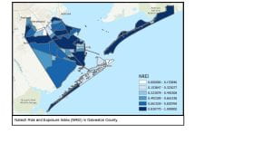
- Natech Risk and Exposure Index (NREI) in Galveston County
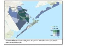
- The CDC/ATSDR Social Vulnerability Index (SVI) and the Natech Risk and Exposure Index (NREI) in Galveston County.
Analytical thematic maps: (please note the all spill volumes are preliminary)
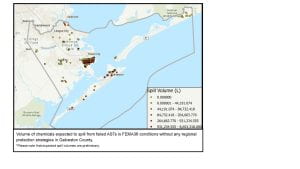
- Volume of chemicals expected to spill from failed ASTs in FEMA36 conditions without any regional protection strategies in Galveston County.
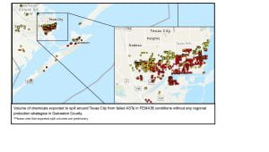
- Volume of chemicals expected to spill around Texas City from failed ASTs in FEMA36 conditions without any regional
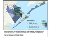
protection strategies in Galveston County. - Expected spill volume (without a regional protection system) due to a FEMA36 event with a bivariate plot of the CDC/ATSDR Social Vulnerability Index (SVI) and the Natech Risk and Exposure Index (NREI) in Galveston County.
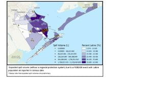
- Expected spill volume (without a regional protection system) due to a FEMA36 event with Latine population as reported in census data.
More information on the Gulf Scholars Program can be found at https://engineering.rice.edu/gsp
* information provided by Valentina Osorio